Pleasant flight along the cliffs from Newhaven. Not enough height or lift to clear the gap at Saltdean. Landed on the beach and enjoyed coffee and cake at the cafe before getting the bus back to Newhaven.


| Duration | 0:00 | Takeoff Distance | 0 |
| Height: | metres |
| Climb: | m/sec |
| Speed: | km/h |
| Distance: | km |
| Height - GPS data | |
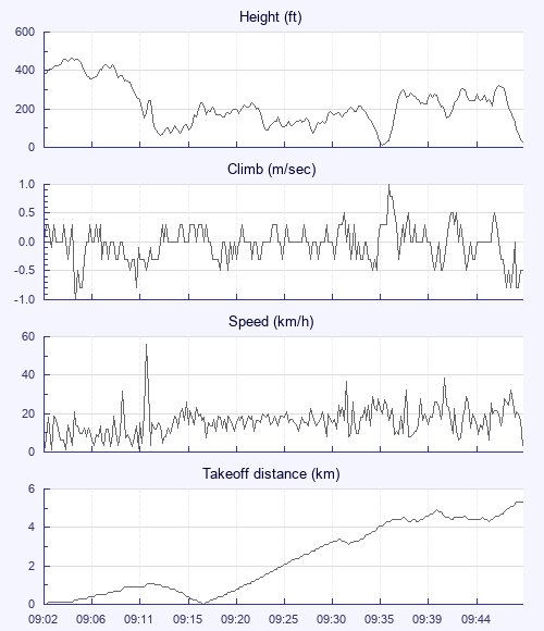
| Maximum Height [09:04:50] |
463 ft |
| Takeoff Height [09:02:21] |
377 ft |
| Landing Height [09:48:40] |
30 ft |
| Total Ascent | 2333 ft |
| Height Gain | |
| Above Takeoff | 85 ft |
| Maximum | 315 ft |
| Low Point [09:35:07] |
7 ft |
| High Point [09:46:30] |
322 ft |
| Units | |
| Climb - Pressure data | |
| Maximum Climb [09:35:40] |
1.0 m/s |
| Minimum Climb [09:05:06] |
-1.0 m/s |
| Units | |
| Speed | |
| Maximum Speed [09:11:46] |
55.8 km/h |
| Average Speed around course |
10.1 km/h |
| Average Speed over track length |
15.7 km/h |
| Units | |
| Tracklog | |
| Flight Duration | 46mins |
| Track Points | 2777 |
| Recording Interval | 1 secs |
| Statistics Interval | 4 secs |
| Track Length | 12.1 km |
| Units | |
| Flight instrument | |
| Type | Flyskyhy |
| Model | 7.3.2 |
| Firmware | 7.3.2 |
Pleasant flight along the cliffs from Newhaven. Not enough height or lift to clear the gap at Saltdean. Landed on the beach and enjoyed coffee and cake at the cafe before getting the bus back to Newhaven.
| Height: | |
| Speed: | |
| Climb: | |
| Distance: |
| Main Map: |
| First Tab: |