Xc Title
User:Guest
Ozone advert
Andrew Craig  All flights
SE Wales League 2023
Flight type image
Turnpoint Flight on a Paraglider
Club
Thames Valley
Glider
Gin Calypso
Date
23rd September 2023
Start
14:05
Finish
15:27
Duration
1hr 21mins
Takeoff
Milk Hill
Landing
Nr Harwell
Coords
Takeoff
51.37868, -1.85550
Start
51.37800, -1.85495
TP1
51.37883, -1.85832
TP2
51.48523, -1.64675
TP3
51.49273, -1.52530
Finish
51.58907, -1.31317
Landing
51.58940, -1.31378
Distances and Score
Leg 1
0.25k
Leg 2
18.88k
Leg 3
8.48k
Leg 4
18.21k
Total
45.82k
Score
45.8
Open Distance
Total
44.5k
Filename
Use full pilot name
Download
Validated
Yes
Flight map
Notes

This map gives an overview of the flight, using the turnpoints to plot the track.

Use the for a detailed map and flight track.

Duration 0:00   Takeoff Distance 0
Controls
To animate the flight: click a point on the track, use the slider, or click the Play button.
slider
slider
Speed
Speed
Slower
Faster
Track color
No data
Highlights
Track data
Time: No data
Height:
Climb:
Speed:
Interval:
Units
Height: metres
Climb: m/sec
Speed: km/h
Distance: km
chart
Notes

Climb and Speed averaged over 4 second intervals.

These values may be lower than those shown by a flight instrument, which has access to continuous raw data.

Metric units are used for all chart data, except for Height which is shown in feet.

Height   -   GPS data
Maximum Height
[14:24:22]
4715 ft
Lowest Save
[14:39:42]
1227 ft
Takeoff Height
[14:05:27]
925 ft
Landing Height
[15:27:15]
390 ft
Total Ascent 9222 ft
Height Gain
Above Takeoff 3789 ft
Units
Climb   -   Pressure data
Maximum Climb
[14:16:43]
3.5 m/s
Minimum Climb
[14:36:47]
-3.0 m/s
Units
Speed
Maximum Speed
[14:26:23]
71.1 km/h
Average Speed
around course
33.8 km/h
Average Speed
over track length
41.4 km/h
Units
Tracklog
Flight Duration 1hr 21mins
Track Points 4909
Recording Interval 1 secs
Statistics Interval 4 secs
Track Length 56.5 km
Units
Flight instrument
Type Syride
Model Sys'Nav Xl
Firmware 1.21
Notes

Climb and Speed averaged over 4 second intervals.

These values may be lower than those shown by a flight instrument, which has access to continuous raw data.

Average Speed around course is measured from Start to Finish points.

Track Length is the cumulative distance between track points from Takeoff to Landing.

You can change the default units displayed - see the Options page.

I used the excellent Wiltshire Connect bus service to get up to Pewsey Downs car park; having made the booking to await Stephen Gray's arrival by train, we got there about noon, and I feared that massive gaggles would fly over our heads as we walked up to the bowl.

But the masses were still there. Clearly it was going to be very busy when climbs appeared, so I sat out the first big gaggle's departure (although Stephen rigged quicky and left with it). It was then hard work for the next 90 minutes, with first too much shade and then a blue hole, although a few more got up from the spur.

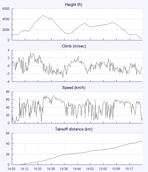
Finally decent cumulus started to appear again, and Glyn and others showed that it was getting lifty. I launched and pushed slightly forward under a few climbing gliders, and soon I was on my way, with only a blue Epsilon coming with me, possibly flown by Tim Crozier-Cole. The initial climb was in the roughest air that I've flown in for years - I got a collapse, which my Calypso dealt with calmly. But, having thought that I'd missed the cross-country bus, I was determined to stay with it, even if led only to a three-kilometre walk back.

We diverged a bit as we searched for better lift, and the Epsilon found a nice climb that was very smooth and took us to base at the A4. As we both pulled in big ears, I lost sight of him and never saw him again. I then found myself under complete shade, and sank steadily until I'd almost reached Aldbourne. I thought there'd be a bus from there, and I was reasonably happy with 20k so late in the day and the season.

But I found a bit of lift, and I suddenly thought: "This could be the last thermal that I fly in for several months! " So I stuck with it, deciding not to bother about retrieve options. The climb was slow but persistent up to over 3,000, and was followed by a long period of zeroes.

By then I was approaching the Ridgeway, and had begun to hope I might reach Didcot for an easy retrieve, but a few last bubbles got me only to the field before the road from the Harwell research centre to Harwell village. I messaged Jim, who'd already got a lift to Didcot station, about the chance of making his train, but the bus from Harwell arrived four minutes too late. I jumped on the next stopping train to Reading - and got off the escalator at platform 7 just as the Pewsey train moved off, with Jim and three other pilots on it.

That would normally have meant a two-and-a-half-hour wait in Reading - but the last Pewsey train was cancelled, so I travelled via Swindon and Westbury, which took almost as long, and arrived just in time to walk down Pewsey High Street as the crowds awaited the carnival procession. September 2023 is turning out almost as good as September 2022.

Use this page to set various display Options. You can choose which units are used to display flight data, which map to show when the starts and which tab to show each time you view a flight.
Units settings

Metric units are used by default for the Statistics and XC Player pages, except for Height data which is shown in feet. You can choose your own custom settings here.

Height:
Speed:
Climb:
Distance:
  Use default
XC Player settings

When the XC Player starts, the track data is shown on the Hybrid map. You can choose a different map here.

Main Map:
  Use default
Tab settings

The first tab shown when you view a flight is the Flight Map. You can choose a different tab here.

First Tab:
  Use default
Notes

This page uses cookies to save your settings for future visits.

If you have disabled cookies for this site then any changes you make will not be saved.