


Having missed the good sky yesterday and scrabbled along low for ages, I made sure to be on site early today. Got to Golden Ball about 09:30. Felt about 15kmh with more in the thermals, and blue, but the one glider was doing pretty well. I was planning on flying with Wez and others who were on the way so I chilled for a while, but in the end couldn't resist taking off, especially when I heard that a few had chosen Milk instead.
Climbs were nice but were not yet pushing through the inversion. I watched as the others arrived, swooped past to say hello and then the hill boomed again, this time with a good solid climb. I was confused why the others were taking so long and thought perhaps it was the numbers limit on the hill so decided I'd better leave. Also, while it was mostly blue over the back, there were some haze caps just starting to appear. The clouds after the downs near Swindon looked really nice so I pushed on.
A few buoyant bits and small climbs took me across the downs and then I got a bit low coming off the high ground near Swindon. Scrabbled out in a gentle lee side from a ploughed field and then a decent climb off the edge of Swindon town.
From then on the sky looked great, but I just couldn't get a handle on how it was working. Large clouds showing lots of movement and growth produced nothing but sink. There were some huge areas of killer sink which was impossible to escape. I never really felt confident when setting off on glide. It seemed like really hard work but with the wind I was covering ground pretty well.
Lots of people had the same thing for the first 1/2 of the flight with quite a few lowish saves in most peoples flights. It felt like I was out of sink with the day, always grovelling in the messy end dregs of thermals and never finding that big smooth moonbeam!
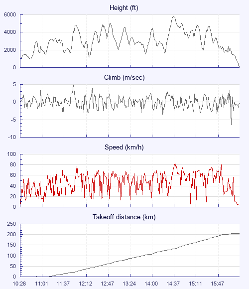
There were a few points where I was pretty sure I was down, especially after some long very sinky glides and this went on until Birmingham where I got properly high again, just ready for the height restricting airspace!
I hadn't copied Wez's goal due to user error on FSH so placed my own pin. Turned out to be just downwind of Crewe and as I arrived comfortably under the 2.5k airspace the town went nuclear. I just couldn't get down. The air was generally rising but with 4 or 5 m/s bullets hammering the glider around. I spiralled hard until vision started to blur and tunnel, but as soon as I came out I just got blasted back up. At one point I was spiralling upwards! Tried running east and west in search of all that lovely sink that had been so prevalent all day but just found violent bullets of lift everywhere. In the end I went downwind (mostly spiralling! ) but I was aware that I didn't have much space before the surface airspace. I think I managed to stay under the ceiling. But it'll be close!
How I wished I had one of the Anti-G chutes, or a glider you could B line but the air was so rough a B line may also have been quiet exciting.
Anyway, I finally found some sink behind a slight hill and stayed there, glorying in the drone of my varios. Landed, kissed the ground (it's while since I've been properly scared in the air), packed and walked to the main road. I'd missed the bus and timing for trains looked a bit tight. I was about to give up on hitching and call a taxi when a lovely lady called Emma who was paying forward a good turn, stopped and gave me a lift to Crewe station. Back to Pewsey at just past 10:00. Tim P gave me a lift to my car and home just after midnight.
Thank god its raining today!