Xc Title
User:Guest
Naviter advert
Steve Watts  All flights
National League 2023
Flight type image
Declared FAI Triangle on a Paraglider
Club
Malvern
Glider
Ozone Photon
Date
15th June 2023
Start
13:59
Finish
18:13
Duration
4hrs 13mins
Takeoff
Worcestershire Beacon
Coords
Takeoff
52.10465, -2.33812
Start
52.10477, -2.33762
TP1
52.29427, -2.11562
TP2
52.08157, -1.91752
Finish
52.10477, -2.33762
Landing
52.12285, -2.32215
Distances and Score
Leg 1
25.98k
Leg 2
27.27k
Leg 3
28.91k
Distance
82.16k
Deductions
2.40k  (cylinders)
Total
79.76k
Multiplier
x 3.00
Score
239.3
Open Distance
Total
29.5k
Filename
Use full pilot name
Download
Validated
Yes
Flight map
Notes

This map gives an overview of the flight, using the turnpoints to plot the track.

Use the for a detailed map and flight track.

Duration 0:00   Takeoff Distance 0
Controls
To animate the flight: click a point on the track, use the slider, or click the Play button.
slider
slider
Speed
Speed
Slower
Faster
Track color
No data
Highlights
Track data
Time: No data
Height:
Climb:
Speed:
Interval:
Units
Height: metres
Climb: m/sec
Speed: km/h
Distance: km
chart
Notes

Climb and Speed averaged over 4 second intervals.

These values may be lower than those shown by a flight instrument, which has access to continuous raw data.

Metric units are used for all chart data, except for Height which is shown in feet.

Height   -   GPS data
Maximum Height
[17:19:23]
6808 ft
Lowest Save
[14:00:44]
2156 ft
Takeoff Height
[13:52:41]
1371 ft
Landing Height
[18:31:05]
325 ft
Total Ascent 36608 ft
Height Gain
Above Takeoff 5436 ft
Maximum 5466 ft
Low Point
[13:53:03]
1342 ft
High Point
as Maximum Height
6808 ft
Units
Climb   -   Pressure data
Maximum Climb
[17:21:58]
4.8 m/s
Minimum Climb
[15:20:46]
-4.3 m/s
Units
Speed
Maximum Speed
[14:51:23]
60.3 km/h
Average Speed
around course
18.9 km/h
Average Speed
over track length
36.3 km/h
Units
Tracklog
Flight Duration 4hrs 38mins
Track Points 16627
Recording Interval 1 secs
Statistics Interval 4 secs
Track Length 168.3 km
Units
Flight instrument
Type Flyskyhy
Model 7.3.2
Firmware 7.3.2
Notes

Climb and Speed averaged over 4 second intervals.

These values may be lower than those shown by a flight instrument, which has access to continuous raw data.

Average Speed around course is measured from Start to Finish points.

Track Length is the cumulative distance between track points from Takeoff to Landing.

You can change the default units displayed - see the Options page.

This morning we had a loose plan of a 55km triangle on the W side of Malvern, on launch that seemed the general consensus too by most with some more ambitious triangles for the Top Guns taking advantage of the stronger Easterly winds early on.

Some of the Malvern crew had a more traditional E side attempt for easier retrieve options (and better public house selection no doubt) but a more difficult 1st leg into wind. Decision time. 🤔

For once my dithering decision making kept me on the ground long enough to see that the E side sky was developing much nicer than the W, decision made.

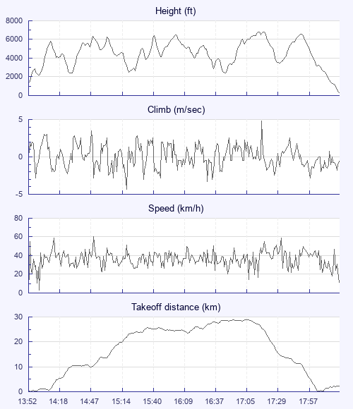
I was in good company out to Worcester with Charles N, Graham S, Dave B and others where they turned with different tasks, from there it was Billy no mates again but good clouds marked the way to Wychbold and onwards all the way to Evesham where after tagging my last turnpoint I gained as much height as possible for the now deteriorating sky looking west.

Just south of Pershore on my last leg I was supprised and relieved to see my flying buddy Gary H suddenly appeared into view ahead, floating out from Malvern marking a climb as if to help guide me back home (I hadn't seen him since launch but later learned after an early bomb he'd yomped back up relaunched and was tagging the last turnpoint on his own 1st successful declared 55km triangle), from there we had a lovely downwind meander back to the Beacon and a debrief over a pint.

Fantastic Malvern day!

Use this page to set various display Options. You can choose which units are used to display flight data, which map to show when the starts and which tab to show each time you view a flight.
Units settings

Metric units are used by default for the Statistics and XC Player pages, except for Height data which is shown in feet. You can choose your own custom settings here.

Height:
Speed:
Climb:
Distance:
  Use default
XC Player settings

When the XC Player starts, the track data is shown on the Hybrid map. You can choose a different map here.

Main Map:
  Use default
Tab settings

The first tab shown when you view a flight is the Flight Map. You can choose a different tab here.

First Tab:
  Use default
Notes

This page uses cookies to save your settings for future visits.

If you have disabled cookies for this site then any changes you make will not be saved.