Xc Title
User:Guest
Ozone advert
James Allen  All flights
SE Wales League 2023
Flight type image
Turnpoint Flight on a Paraglider
Club
Thames Valley
Glider
Ozone Mantra m7
Date
8th April 2023
Start
13:14
Finish
15:01
Duration
1hr 46mins
Takeoff
Golden Ball
Landing
Nr Stroud
Coords
Takeoff
51.37282, -1.82065
Start
51.37267, -1.81705
TP1
51.47102, -1.93802
TP2
51.52717, -1.93433
TP3
51.74825, -2.20913
Finish
51.74150, -2.22157
Landing
51.74132, -2.21978
Distances and Score
Leg 1
13.80k
Leg 2
6.25k
Leg 3
31.10k
Leg 4
1.14k
Total
52.29k
Score
52.3
Open Distance
Total
49.9k
Filename
Use full pilot name
Download
Validated
Yes
Flight map
Notes

This map gives an overview of the flight, using the turnpoints to plot the track.

Use the for a detailed map and flight track.

Duration 0:00   Takeoff Distance 0
Controls
To animate the flight: click a point on the track, use the slider, or click the Play button.
slider
slider
Speed
Speed
Slower
Faster
Track color
No data
Highlights
Track data
Time: No data
Height:
Climb:
Speed:
Interval:
Units
Height: metres
Climb: m/sec
Speed: km/h
Distance: km
chart
Notes

Climb and Speed averaged over 4 second intervals.

These values may be lower than those shown by a flight instrument, which has access to continuous raw data.

Red values indicate suspect data, because the tracklog contains invalid points.

Metric units are used for all chart data, except for Height which is shown in feet.

Height   -   GPS data
Maximum Height
[14:23:47]
5374 ft
Lowest Save
[13:51:25]
1053 ft
Takeoff Height
[13:13:37]
879 ft
Landing Height
[15:02:25]
203 ft
Total Ascent 16401 ft
Height Gain
Above Takeoff 4495 ft
Maximum 4498 ft
Low Point
[13:13:40]
876 ft
High Point
as Maximum Height
5374 ft
Units
Climb   -   GPS data
Maximum Climb
[14:49:01]
6.3 m/s
Minimum Climb
[14:55:17]
-6.3 m/s
Units
Speed
Maximum Speed
[14:57:13]
76.5 km/h
Average Speed
around course
29.4 km/h
Average Speed
over track length
42.3 km/h
Units
Tracklog
Flight Duration 1hr 48mins
Track Points 6529
Recording Interval 1 secs
Statistics Interval 4 secs
Track Length 76.7 km
Invalid Positions
[< 1%]
6
Units
Flight instrument
Type Samsung Sm-g998b 13
Model Not Set
Firmware 0.9.8.6
Notes

Climb and Speed averaged over 4 second intervals.

These values may be lower than those shown by a flight instrument, which has access to continuous raw data.

Red values indicate suspect data, because the tracklog contains invalid points.

Average Speed around course is measured from Start to Finish points.

Track Length is the cumulative distance between track points from Takeoff to Landing.

You can change the default units displayed - see the Options page.

Well, my first proper cross country flight in almost 3 years!

This flight is part of a closing chapter on a journey of fear injury recovery, which began in late 2019 following a reserve ride from base.

Immediately following that, covid lockdowns allowed my most recent and significant paragliding memory to be one of a near miss that could have ended very badly. Had covid had not hit, I have no doubt that I would have brushed it off as a bad day, but it did, and I couldn't.

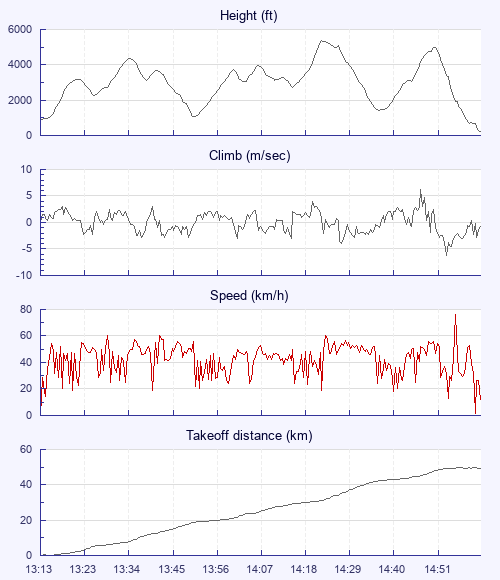
Anyway, the forecast was mixed, with winds a bit light for open distance, but a bit strong for a tri. My mates had lofty plans, but I only had until 4pm to fly, expected at a bbq at 5. They all climbed out ahead of me, and for the first time in at least 3 years, I felt a genuine jealousy as they caught successive climbs and began their adventures. Eventually my turn came, though by that point I was going to be flying alone. The first climb was nice. I'd climbed out of golden ball so many times that I was used to the view, and I felt at ease over the Pewsey downs.

The first glide brought on some second thoughts of doubt. The ever-present worry of a single bubble of sharp air causing a collapse at height, my biggest fear, was there. But I remembered just how well loaded and safe my wing was, pushed about half bar, and continued.

A few climbs later, I was working my way around airspace and feeling good. For the first time in a while, the ground started getting close, and I started feeling worse. For almost 3 years now, earth's embrace had been welcoming, but now it was a reminder that the fuel tank was running out, and I needed a climb. A ploughed field delivered, and I caught a boomer to base.

Today was a bit inversed in that the usual 'softer at base' rule didn't apply. The lift seem to concentrate and roughen at height. It took some mental resetting to not let this worry me, and I hooked a few more iffy climbs until the stroud valley came into view.

At that point, I was being swamped by the gliders out of Leckhampton. Mostly below me, like circling sharks, I reminded myself that my flarm was keeping me safe.

Wary of the time, I opened google maps and checked stroud train station times. Almost as if meant to be, one was leaving just 30 minutes from now. I took one last climb almost to base directly above Stroud, then put in nice docile spirals all the way down to a field near the train station.

A hugely confidence building moment was staying cool and collected even when fighting small bubbles of lift, into a small ish field in the middle of a built up area in a valley. I'm often told that my interpretation of risk is entirely inverse to how it should be, and choosing to land in the middle of a town in thermic air was a reminder of that.

Anyway, I landed with a smile. In a nutshell, I'd semi-enjoyed it. I'd be lying if I said it felt as good as it did 3 years ago, and I now think while my fear recovery journey is ending, my 'learning to love xc again' journey is just beginning. Life begins at +1ms.

Use this page to set various display Options. You can choose which units are used to display flight data, which map to show when the starts and which tab to show each time you view a flight.
Units settings

Metric units are used by default for the Statistics and XC Player pages, except for Height data which is shown in feet. You can choose your own custom settings here.

Height:
Speed:
Climb:
Distance:
  Use default
XC Player settings

When the XC Player starts, the track data is shown on the Hybrid map. You can choose a different map here.

Main Map:
  Use default
Tab settings

The first tab shown when you view a flight is the Flight Map. You can choose a different tab here.

First Tab:
  Use default
Notes

This page uses cookies to save your settings for future visits.

If you have disabled cookies for this site then any changes you make will not be saved.