Xc Title
User:Guest
Ozone advert
Carl Foster  All flights
National League 2022
Flight type image
Tow-launch Turnpoint Flight on a Paraglider
Club
Norfolk
Glider
Ozone Delta 4
Date
6th August 2022
Start
13:11
Finish
17:05
Duration
3hrs 53mins
Takeoff
Hill Farm
Landing
Nr Babergh District
Coords
Takeoff
52.69152, 0.81753
Start
52.69207, 0.80920
TP1
52.52307, 1.12592
TP2
52.15280, 1.14465
TP3
51.97423, 1.03398
Finish
51.96582, 0.99288
Landing
51.96412, 0.99545
Distances and Score
Leg 1
28.53k
Leg 2
41.22k
Leg 3
21.27k
Leg 4
2.98k
Total
94.00k
Score
94.0
Open Distance
Total
82.1k
Filename
Use full pilot name
Download
Validated
Yes
Flight map
Notes

This map gives an overview of the flight, using the turnpoints to plot the track.

Use the for a detailed map and flight track.

Duration 0:00   Takeoff Distance 0
Controls
To animate the flight: click a point on the track, use the slider, or click the Play button.
slider
slider
Speed
Speed
Slower
Faster
Track color
No data
Highlights
Track data
Time: No data
Height:
Climb:
Speed:
Interval:
Units
Height: metres
Climb: m/sec
Speed: km/h
Distance: km
chart
Notes

Climb and Speed averaged over 4 second intervals.

These values may be lower than those shown by a flight instrument, which has access to continuous raw data.

Metric units are used for all chart data, except for Height which is shown in feet.

Height   -   GPS data
Maximum Height
[16:39:55]
5869 ft
Lowest Save
[13:36:00]
1027 ft
Takeoff Height
[13:09:31]
240 ft
Landing Height
[17:07:36]
-26 ft
Total Ascent 32503 ft
Height Gain
Above Takeoff 5630 ft
Units
Climb   -   Pressure data
Maximum Climb
[13:42:23]
5.8 m/s
Minimum Climb
[13:35:03]
-4.8 m/s
Units
Speed
Maximum Speed
[16:08:31]
63.0 km/h
Average Speed
around course
24.1 km/h
Average Speed
over track length
36.9 km/h
Units
Tracklog
Flight Duration 3hrs 58mins
Track Points 14286
Recording Interval 1 secs
Statistics Interval 4 secs
Track Length 146.5 km
Units
Flight instrument
Type Naviter
Model Oudie N
Firmware 2.5.1+1468
Notes

Climb and Speed averaged over 4 second intervals.

These values may be lower than those shown by a flight instrument, which has access to continuous raw data.

Average Speed around course is measured from Start to Finish points.

Track Length is the cumulative distance between track points from Takeoff to Landing.

You can change the default units displayed - see the Options page.

It's been a tough stressful week in work with still more to do by Monday, but the temptation of the forecast was too much.

Got to the field early and set up ready, drew cards for winch duties only two operators, I drew the low card and therefore got to fly first. But two unsuccessful flights seen me on the winch for the next 8 lines, just finished the first 4 when another winch operator Bill arrived and insisted to take over the next 4. Not one to argue I rushed back to launch to get ready. Big queue saw me take the 1st line of the 2nd set, so one opportunity before my turn on the winch again.

Now on to the flight, really poor tow as the bridal caught my phone case, knocked my phone out off the case and I some how managed to catch it as it fell off my flight deck. Letting go of the controls, made me go off line. Trying to reattach it somewhere safe, the winch operator must of thought I was having an epileptic fit going up the line.

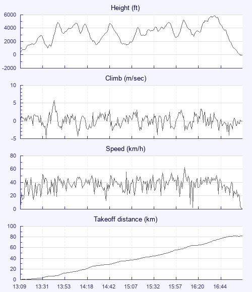
Off tow low I didn't expect much but managed to scrape up out of the field it was generally rough and broken not what I was expecting. Took me a while to get really established and even then wasn't too convinced it would work that well. I had set my plan to meet the sea breeze and surf it as far as I can. It almost worked perfectly, I soared along the sea Breeze with clouds forming below me and around me it was just amazing. Eventual just before Colchester I hit head wind and seeing a lovely spot to land by the river and boat yard and needing a pee the temptation was too strong to try and fight on for a few more Km's. As nice as it would be to make a 100km flight, its going to have to wait.

On landing, I was mobbed by a young lad asking loads of questions and trying to help, eventually got packed up, got offered a lift from a lovely lady with a child, husband didn't seem too impressed though got me to the nearest train station just in time, train arrived very shortly, toilets out of order, arrived in Norwich an had to run from Train station to bus station, they are not near each other, just made it, then realised I still hadn't had a pee.

All in all a great day, massive thanks to Bill for taking over on the winch when he did.

Use this page to set various display Options. You can choose which units are used to display flight data, which map to show when the starts and which tab to show each time you view a flight.
Units settings

Metric units are used by default for the Statistics and XC Player pages, except for Height data which is shown in feet. You can choose your own custom settings here.

Height:
Speed:
Climb:
Distance:
  Use default
XC Player settings

When the XC Player starts, the track data is shown on the Hybrid map. You can choose a different map here.

Main Map:
  Use default
Tab settings

The first tab shown when you view a flight is the Flight Map. You can choose a different tab here.

First Tab:
  Use default
Notes

This page uses cookies to save your settings for future visits.

If you have disabled cookies for this site then any changes you make will not be saved.