Xc Title
User:Guest
UK Airsports advert
Alastair Tytler  All flights
National League 2017
Flight type image
Turnpoint Flight on a Paraglider
Club
LLSC
Glider
Nova Mentor 4
Date
31st May 2017
Start
15:28
Finish
17:24
Duration
1hr 55mins
Takeoff
Craig Mhor
Landing
Fortingall
Coords
Takeoff
56.33348, -4.41233
Start
56.33272, -4.41410
TP1
56.37877, -4.36568
TP2
56.36643, -4.34353
TP3
56.49132, -4.33652
Finish
56.60272, -4.02900
Landing
56.60095, -4.03102
Distances and Score
Leg 1
5.94k
Leg 2
1.94k
Leg 3
13.91k
Leg 4
22.62k
Total
44.41k
Score
44.4
Open Distance
Total
38.3k
Filename
Use full pilot name
Download
Validated
Yes
Flight map
Notes

This map gives an overview of the flight, using the turnpoints to plot the track.

Use the for a detailed map and flight track.

Duration 0:00   Takeoff Distance 0
Controls
To animate the flight: click a point on the track, use the slider, or click the Play button.
slider
slider
Speed
Speed
Slower
Faster
Track color
No data
Highlights
Track data
Time: No data
Height:
Climb:
Speed:
Interval:
Units
Height: metres
Climb: m/sec
Speed: km/h
Distance: km
chart
Notes

Climb and Speed averaged over 4 second intervals.

These values may be lower than those shown by a flight instrument, which has access to continuous raw data.

Metric units are used for all chart data, except for Height which is shown in feet.

Height   -   GPS data
Maximum Height
[16:29:56]
5322 ft
Lowest Save
[16:19:46]
2385 ft
Takeoff Height
[15:27:32]
1906 ft
Landing Height
[17:26:25]
394 ft
Total Ascent 12221 ft
Height Gain
Above Takeoff 3415 ft
Maximum 3422 ft
Low Point
[15:27:34]
1900 ft
High Point
as Maximum Height
5322 ft
Units
Climb   -   Pressure data
Maximum Climb
[16:12:54]
6.0 m/s
Minimum Climb
[16:31:36]
-5.7 m/s
Units
Speed
Maximum Speed
[17:16:25]
79.2 km/h
Average Speed
around course
23.1 km/h
Average Speed
over track length
36.2 km/h
Units
Tracklog
Flight Duration 1hr 58mins
Track Points 1996
Recording Interval 4 secs
Statistics Interval 4 secs
Track Length 71.8 km
Units
Flight instrument
Type Flyskyhy
Model 6.1
Firmware 6.1
Notes

Climb and Speed averaged over 4 second intervals.

These values may be lower than those shown by a flight instrument, which has access to continuous raw data.

Average Speed around course is measured from Start to Finish points.

Track Length is the cumulative distance between track points from Takeoff to Landing.

You can change the default units displayed - see the Options page.

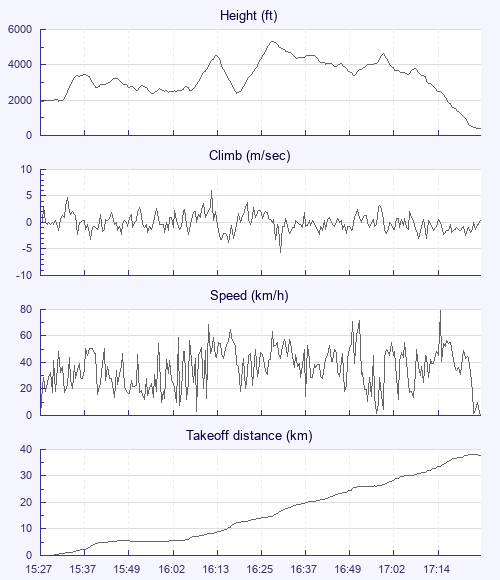
Definitely a game of two half's and the first was unfortunately very frustrating. Being a little later to leave the house I met up with Bob G. Tim B. And Trias at Aberfoyle. By the time we got to launch, conditions were looking good. Once set up I went to tuck my trousers into my socks and put on my ankle gaiters but found the hem of my trousers covered in tiny ticks just waiting their chance, I bet that's not in any of the site guides, most tick infested site in Scotland. Where's the tick magnet Mr P. When you need him! And we are off, after a couple of climbs I am at base and as I head off I can see I am already miles behind the others as they are already climbing Ben Ledi. Once there I get a rather rowdy climb to base and then start drifting NW along the ridge, although in sun there was little lift and the further I get, the lower I get until the whole area ahead was shaded out and I landed one valley before Balquhidder, bugger! I remember sitting there on the grass saying "I just don't get it. "

Not fancying another hike out and sore feet decided to see what could be salvaged, at least a glide out to the road perhaps. Feeling rather despondent I walk up to the end of a small, into wind ridge before relaunching into a light thermic breeze. Not finding much lift, I head east and at the end of the ridge find a nice climb to around 3.5 so head over to Balquhidder. As usual I am late, only one glider still there on the hill. Small broken thermal on the SW face but eventually find a nice climb that takes me up and over the back. Now I start to relax into cruising mode and head over to Glen Dochart and find another long slow climb taking me to Killin. Happy again! It's around 5pm and sky is now pretty blue and the views are just stunning as I head over to Tarmachan and then onto Ben Lawers where I meet up with a Rush and we climb up the front of the hill before taking a few turns above the summit and I head off down the ridge landing just past Fortingall. Followed by a lift to Aberfeldy from a couple of the Aberdeen boys, thanks, a bus to Perth, a bus the Stirling and a lift back out to Aberfoyle to pick up the cars. A hugely frustrating yet inspiring sort of a day. The word fun seems just totally inadequate. I'll get it right next time Bren, next time!

Use this page to set various display Options. You can choose which units are used to display flight data, which map to show when the starts and which tab to show each time you view a flight.
Units settings

Metric units are used by default for the Statistics and XC Player pages, except for Height data which is shown in feet. You can choose your own custom settings here.

Height:
Speed:
Climb:
Distance:
  Use default
XC Player settings

When the XC Player starts, the track data is shown on the Hybrid map. You can choose a different map here.

Main Map:
  Use default
Tab settings

The first tab shown when you view a flight is the Flight Map. You can choose a different tab here.

First Tab:
  Use default
Notes

This page uses cookies to save your settings for future visits.

If you have disabled cookies for this site then any changes you make will not be saved.