Xc Title
User:Guest
Cloudbase Paragliding advert
Wayne Seeley  All flights
National League 2016
Flight type image
Turnpoint Flight on a Paraglider
Club
XClent
Glider
Niviuk Icepeak 6
Date
31st March 2016
Start
11:56
Finish
15:50
Duration
3hrs 53mins
Takeoff
Leckhampton Hill,GB
Landing
Nr Whitcombe
Coords
Takeoff
51.86480, -2.06575
Start
51.86482, -2.06575
TP1
51.86772, -2.05902
TP2
51.87122, -2.07253
TP3
50.77620, -2.33450
Finish
50.67633, -2.41833
Landing
50.67640, -2.41690
Distances and Score
Leg 1
0.57k
Leg 2
1.01k
Leg 3
123.19k
Leg 4
12.59k
Total
137.36k
Score
137.4
Open Distance
Total
135.1k
Filename
Use full pilot name
Download
Validated
Yes
Flight map
Notes

This map gives an overview of the flight, using the turnpoints to plot the track.

Use the for a detailed map and flight track.

Duration 0:00   Takeoff Distance 0
Controls
To animate the flight: click a point on the track, use the slider, or click the Play button.
slider
slider
Speed
Speed
Slower
Faster
Track color
No data
Highlights
Track data
Time: No data
Height:
Climb:
Speed:
Interval:
Units
Height: metres
Climb: m/sec
Speed: km/h
Distance: km
chart
Notes

Climb and Speed averaged over 4 second intervals.

These values may be lower than those shown by a flight instrument, which has access to continuous raw data.

Red values indicate suspect data, because the tracklog contains invalid points.

Metric units are used for all chart data, except for Height which is shown in feet.

Height   -   Pressure data
Maximum Height
[15:16:11]
5210 ft
Lowest Save
[13:13:03]
1093 ft
Takeoff Height
[11:56:57]
922 ft
Landing Height
[15:51:00]
305 ft
Total Ascent 29882 ft
Height Gain
Above Takeoff 4288 ft
Maximum 4291 ft
Low Point
[11:57:01]
919 ft
High Point
as Maximum Height
5210 ft
Units
Climb   -   Pressure data
Maximum Climb
[13:31:59]
5.5 m/s
Minimum Climb
[13:03:11]
-5.5 m/s
Units
Speed
Maximum Speed
[12:14:24]
80.1 km/h
Average Speed
around course
35.3 km/h
Average Speed
over track length
46.0 km/h
Units
Tracklog
Flight Duration 3hrs 54mins
Track Points 8829
Recording Interval 2 secs
Statistics Interval 4 secs
Track Length 179.3 km
Invalid Positions
[< 1%]
28
Units
Flight instrument
Type Flyskyhy
Model 5.0
Firmware 5.0
Notes

Climb and Speed averaged over 4 second intervals.

These values may be lower than those shown by a flight instrument, which has access to continuous raw data.

Red values indicate suspect data, because the tracklog contains invalid points.

Average Speed around course is measured from Start to Finish points.

Track Length is the cumulative distance between track points from Takeoff to Landing.

You can change the default units displayed - see the Options page.

Good old Leckhampton delivers again, Having already had one good XC from there in febuary this day was looking alot better for a trip to the coast.

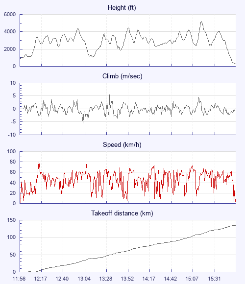
Arriving late after work (11:45) the hill was silly busy and as i rigged the first gaggle climbed out and soon hit the very low base but it was working, I took off at 11:55 into the melee and two buzzards way out front showed me an escape route, i took a nice climb out on my own just as another climb full off gliders climbed just along side of me and soon we were all at base, the first gaggle had flown south already hoping to fly east of kemble? Watching my instruments through the climb out the wind was clearly nnw/nw and having set goal at Weymouth i quickly made the decision to push west hard to fly north of kemble already worrying about the sailsbury danger area (80km away) followed by Graham Steel, Guy Anderson, Joe Dart and a few others chasing lower. Although Base was still quite low the clouds were close together and i pushed on easily passing kemble where we could finally head slighlty more south, nearing the M4 i pushed to hard and flew throu a climb and got low, grey and guy took the climb behind me and as i grovelled out low from a tractor they cruised over my head at base. Now on my own i climbed back out and it was Banging for the nxt 30k with predictable strong climbs and i kept pushing west aimimg for westbury town. I had now caught grey and guy who were having to push hard across the front of the danger zone past westbury as they had taken a more southerly route than i had, we almost met up just north of warminster but i decided to keep pushing more west as it was still nnw hoping it would make getting to goal easier, also by now joe dart was always somewhere nearby so thought i had options if i got stuck. Cruised over Longleat then got really low approaching the back of Mere. Had to go into full on survival mode to stay in the air in quite a big blue hole as graham and guy raced off ahead, joe flew past and also mariusz flew straight over me on his way to the coast. Once back up it was easy and was soon 20ish km from goal at 5200ft. I needed one more climb from a cloud crosswind that would have left a very easy glide into goal at 144km, or head downwind where joe was(which would have been the better option to extend the flight but i had goal fixation) but it wasnt to be, couldnt find the climb crosswind and landed short. Quick bus to the beach to meet up with everyone else then a beer and atrain ride home with 6 of my mates: ) 2016 has started for sure.

Use this page to set various display Options. You can choose which units are used to display flight data, which map to show when the starts and which tab to show each time you view a flight.
Units settings

Metric units are used by default for the Statistics and XC Player pages, except for Height data which is shown in feet. You can choose your own custom settings here.

Height:
Speed:
Climb:
Distance:
  Use default
XC Player settings

When the XC Player starts, the track data is shown on the Hybrid map. You can choose a different map here.

Main Map:
  Use default
Tab settings

The first tab shown when you view a flight is the Flight Map. You can choose a different tab here.

First Tab:
  Use default
Notes

This page uses cookies to save your settings for future visits.

If you have disabled cookies for this site then any changes you make will not be saved.