


First - where to go? I couldn't face the drive to Wales, and wasn't even sure which site there would be best. So it was Leckhampton or Westbury. Indolence took me to the latter - I can't pretend it was fear of crowding at Lecky (I expected most to get away quickly) or the difficulty of slope landing, as Westbury isn't ideal for that, anyway. And with strong wind forecast, slope landing was unlikely to be necessary.
I've never flown cross-country from Westbury before, but with the corner of Salisbury Plain airspace opened to us (thanks, Nick Somerville of the Avon club), it looked feasible to push out to Westbury town and then head south over Warminster. Soon after I arrived the sky began to look very good, and the first glider to launch went up quickly.
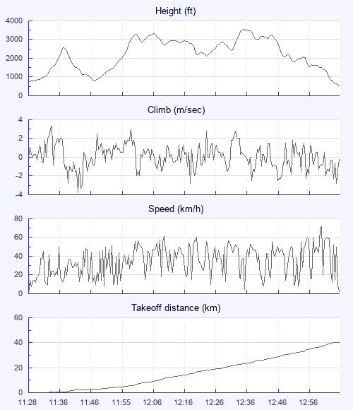
I launched at 1130. My first climb took me back towards the airspace, but it was also easy to climb out front. At 2500 feet ASL, seeing a juicy cloud over the town, I decided it was time to put the plan into action. But I sank badly on my crosswind glide, and found only scraps when I got there. You idiot, I said to myself: You've gone too soon, too low, and too alone. Circling in less than zero, I descended to 800 feet, and wondered whether to land in Westbury and get a taxi back up, or join the pilot of a Delta that I saw landing in a field to the south - he might have a lift arranged.
But the scraps coalesced, and I concluded that fighting to keep going offered better odds than going back to start again. Meanwhile, gliders began to arrive much higher over the town, promising me company if I could stay up. I could, and I was joined by a grey Icepeak with a number on it - Simon Twiss? - who outclimbed me and pressed on alone. That left me with Dave Cox on his 777 Queen and someone on a luminous green Artik 4.
We helped each other nicely, taking turns in leading, following, and finding lift. But the northerly wind was taking us towards Compton Abbas airfield. It showed red on my Oudie, but the information field said Class G - were we allowed to fly over it? I missed a chance to shout an inquiry to one of my companions, as Dave headed east towards his Weymouth goal, while the Artik took a climb right over the runway - perhaps high enough to clear a putative ATZ. I decided not to risk crashing it, so followed Dave. As he landed, I got a weak climb, but I couldn't get properly high again.
Arriving low at what I later discovered to be Hambledon hill fort, I remembered some recent advice: That when flying at a site and deciding when to go XC, you should imagine that you've arrived there from somewhere else, and make your decisions accordingly. This was probably a case when the opposite applied: I should have settled in to soar until a climb appeared, but instead I went over the north face in a mere blip. Given the strongish wind, I decided against continuing off the downwind edge of the small plateau in the hope of a lee-side thermal, and landed on top.
43k was a good result - but it was still only ten past one, and the sky remained epic. The coast would have been even nicer; some made it there from Leckhampton and Monksdown.
I could see a main road a mile or so away, and walked down the hill to the edge of the Ranston estate, with its big manor house, where a sign read: "Private - no right of way. " I couldn't see another way to the road, so continued until I was accosted by an aggrieved tractor driver. He advised me to leave quickly, saying that if his boss saw me, he'd be REALLY grumpy.
I walked a fair way along the A350 until I came to a quarter-decent spot for hitching. Over half an hour passed with cars zooming by before a driver stopped, saying he'd seen something on my sign about a glider, and had gone around the block to come back and pick me up. He knew Westbury White Horse, and was happy to divert from his route to Corsham to take me all the way up the hill. What a nice man. So what had threatened to be a nightmare retrieve suddenly became a very easy - and free - ride.
And it's still only March!