


This flight is what I consider to be my first climb out over the back of the hill and has been a long time coming. Always missing the chance or not being on the right hill at the right time.
My previous best have been a couple of 25K flights from the tow field in Norfolk, and a 41K guided flight with help in Laragne. So for me, this is by far my PB.
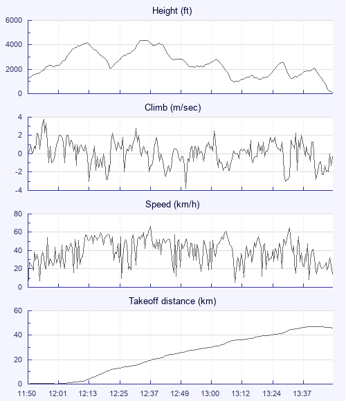
I launched straight into a thermal and was ahead of the gaggle forming, which helped me a lot, but I found it very stressful as it got busier and busier, for the first time ever I stuck with it, climbing out to probably 2000ft ish, Eventually I realised I wasn't climbing as well as I could be due to the gaggle so decided to leave it and push back to the hill, this was good for me as it gave me some time to compose myself and relax a little. I was fortunate to stay with the climb just a little lower and weaker than the main gaggle now heading off. I climbed with two or three other gliders there or there about, which was much less stressful.
Getting to 3,000ft I though about heading off on glide but the climb seemed to be still working so I thought 3,500 I 'll head off, that turned into 4,000ft and finally I set off on glide, Seeing Stanage Edge in the distance I was hoping to make it there at least, (having had a site brief about Eyam and the sensitivity of Stanage, should we land anywhere around that area was a little worrying) but getting to Stanage with 3,000ft I carried on and aimed for the northern side, (as briefed, it tended to work better) still not finding a climb and seeing the other pilots I was with stop before or on stanage, I pressed on, relaxing a little as I past the point where we were told ""try not to land anywhere you shouldn't"
By now the sky was getting full and fairly dark, I carried on hoping to get a climb off the trees by the 3 reservoirs, but no such luck. I felt I was starting to get low and was keeping my options open for a landing field. I could see the remains of the initial gaggle up front a lot higher, which I thought would be way out of gliding distance. With a stiff breeze behind us and plenty of landing options I pressed on. Finally catching the others ahead of me up, on the next bit of high ground north of the 3 reservoirs. Although, I was a good 500 - 1000ft lower, I joined their climb. (Task Rules was to turn left the last few days, and by now everyone was turning right, I didn't think this was a problem as didn't realise I favoured one side or the other, until now, and right wasn't it; -) Scrambling about a little to get consistent turns. As soon as the others Simon Blake, John Murphy and a few others cleared the area I reversed my turn and climbed more successfully to my left. Trailing behind the others again by now, I made a good climb near enough to base leaving some margin of error at around 4,300ft.
After the glide from base I joined up with John Murphy (artik 4) Mark Smith (Peak 3? ) a dark coloured (Gradiant Aspen? ), Simon and others seemed to have pushed on a little.
I noticed John on the Artik move his glide more to the East and I carried on a North East Direction, aiming for an industrial Estate, Keeping an eye on the Artik I could see he found a good climb from the village, but by now I thought it would be a hard slog for me to try an fly up wind to his climb and set about on best glide to get above the industrial estate. (on hands up my glider started turning right "eastwards" it felt like it turned me 180 degrees, but it was probably just more like than 90 or so, ( I have heard how these new gliders will find lift better than the pilot so I let it go) Sure enough it took me right under the path of the Artik, thermaling towards me, bonus. I didn't get the height of John and seemed to lose the lift shortly after a small climb. So I carried on.
My next climb came as I passed over the village or Birdwell. I remember looking at my oudie and it was telling me I needed a glide ratio of around 25 to make goal, next time a looked it was something like 18. And after getting very low around 950ft with 6-7km to go, I got a weak saving climb from the village of Cudworth, having flown over a little close with all the houses having solar panels, I got a weak lift I wouldn't exactly call it a climb but my altitude did appear to be going up very slowly and got me to the next village of Brierley, I then saw two seagulls thermalling which turned into about 40 or more thermalling low down. I milked this for more than I probably needed to because next time I notice my glide to goal was something like 2.5 and at 2500ft I set off on final glide.
Having picked out a nice huge playing field to land in, I got a great thermal feeling pretty consistent and strong (ish), I was undecided to whether to go with it and carry on as I knew this task was around 43KM. I thought my first 50K would be in the bag if I carried on. Having totally relaxed having made goal, thermalling felt so much easier. Another pilot was landing in the same field, so I thought it would be much more rewarding to land with someone else from the comp and get a good retrieve than go on alone and land not knowing where possibly another 5-10k maybe more but who knows and who cares I just made a PB flight.
Not having much experience of flying this kind of distance, what amazed me was the amount of ground you can cover circling in zero's and how much ground I actually covered setting off on a down wind glide.
So a big thanks to the BP Cup as without it I would probably be still wanting to make my first 50km (Another bonus was not realising until I entered the flight that I actual got my first 50K flight.