


The Dyke, the Gibbet, Frocester, Selsley, Leckhampton, Uffington, Liddington -- Facebook and Telegram buzzed with discussion. I went for Combe Gibbet as being the right direction, without sea or complicated airspace too close… And if the big and medium guns went elsewhere, so much the better for a uncrowded hill.
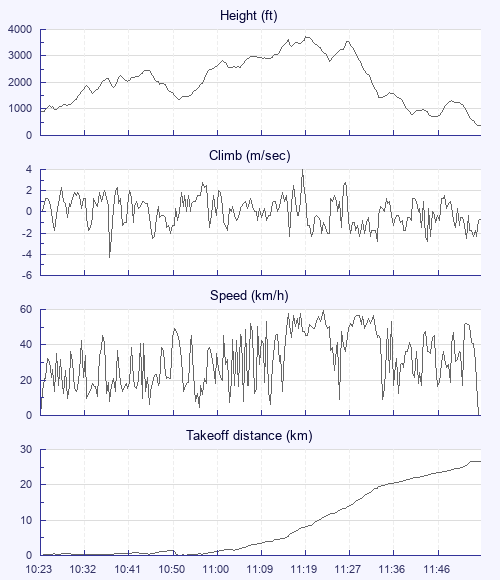
I arrived just before sunset the night before; the breeze felt soarable, and the moon was almost full, but my bed called me. Mike was flying in the morning when I emerged at about 0800, reporting it not too lovely. But when I launched at 1023, it was not as strong, nor as rough, as the chat on the hill had suggested.
I resolved not to go over the back without good cause, and so pootled around, along and in front of the hill for a while. Eventually a climb appeared that was too steady, if not too strong, to abandon; I shared it with Polish Lester on a UP Edge and Czech Ludek on an Axis Polaris. Lester wandered off further west, but eventually I found myself chasing him with Ludek no longer around. I applied big ears a couple of times at base, but the suck was not huge.
My timidity with the bar hurt me as I arrived at Overton later and lower than Lester, and couldn't connect with his climb. A red kite saved me for a while, but lacked the concentration to make a really good XC pilot - it buggered off to have its lunch, I think. A dark field, a tractor and a flock of seagulls failed to give me a last-ditch save, and I came down at the edge of the ploughed field -- then had to scamper into the hedgerow as the cheery ploughman reduced the grassy edge still further.
After a fair wait, during which Crispin rang to say he was down nearby, I got a lift from a charming young mother, who was curious about my Glider Pilot Need Lift sign, and described herself as a hippy who gave lifts because it would give her karma - although she was an executive of a software firm and didn't look like a hippy at all. She dropped me at the A34, and after another longish wait, along came Emil Van Wyk's wife, who was on her district nurse rounds, saw my bag and kindly went out of her way to drop me north of Andover.
A few minutes later, two lads -- in some parts of the world they might be called neds, yobs or larrikins, but not by me -- drove past in a tatty Vauxhall, hooting and gesticulating. I thought it might just be possible that they were offering a lift, so ran a good 300 metres to find them waiting a bit sheepishly in a layby. A stilted but polite conversation made the situation clear; their car had about an eggcup of fuel in it; I needed a lift to Combe Gibbet; they had no money; I had some money. I gladly offered them a tenner to take me there. After putting exactly £10 of fuel in, we took the back roads near Faccombe, where a fat pheasant trotted along the tarmac ahead of us. The driver will slow down, I thought, but no; he sped up, gave the pheasant a good whack and stopped, declaring: "That's my dinner - I haven't had a roast for ages. " He jumped out, only to return empty-handed. "The bugger kept running! " he complained. A tough bird… The driver apologised; no need, I said -- I wouldn't do it myself, but it's certainly no worse than buying a chicken in Sainsbury's.
The lads were astonished to hear that I'd flown nearly to Basingstoke from the Gibbet -- where they often went shooting for semi-legal prey -- and were delighted to see gliders still flying there. Over tea and biscuits, I advised them that if they contacted the local school, said they'd brought a pilot back from an XC, and mentioned that they were short of funds, they might get a good deal on a tandem flight each.
In a further piece of serendipity, they got talking to Graham Steel, who'd flown from Selsley to near Whitchurch, got a lift as far as the Gibbet, but still needed a lift to Cheltenham. He had money… They needed more fuel… The wheels of the economy turned a few more revolutions.