Xc Title
User:Guest
Naviter advert
James Allen  All flights
Avon League 2019
Flight type image
Turnpoint Flight on a Paraglider
Club
Thames Valley
Glider
Triple Seven Queen 2
Date
13th August 2019
Start
11:44
Finish
13:26
Duration
1hr 42mins
Takeoff
Westbury
Landing
Nr Great Bedwyn
Coords
Takeoff
51.26225, -2.14825
Start
51.26562, -2.14785
TP1
51.25938, -2.15397
TP2
51.27200, -2.13628
TP3
51.26587, -2.14267
Finish
51.36910, -1.59672
Landing
51.36917, -1.59683
Distances and Score
Leg 1
0.81k
Leg 2
1.87k
Leg 3
0.82k
Leg 4
39.76k
Total
43.26k
Score
43.3
Open Distance
Total
40.8k
Filename
Use full pilot name
Download
Validated
Yes
Flight map
Notes

This map gives an overview of the flight, using the turnpoints to plot the track.

Use the for a detailed map and flight track.

Duration 0:00   Takeoff Distance 0
Controls
To animate the flight: click a point on the track, use the slider, or click the Play button.
slider
slider
Speed
Speed
Slower
Faster
Track color
No data
Highlights
Track data
Time: No data
Height:
Climb:
Speed:
Interval:
Units
Height: metres
Climb: m/sec
Speed: km/h
Distance: km
chart
Notes

Climb and Speed averaged over 4 second intervals.

These values may be lower than those shown by a flight instrument, which has access to continuous raw data.

Red values indicate suspect data, because the tracklog contains invalid points.

Metric units are used for all chart data, except for Height which is shown in feet.

Height   -   Pressure data
Maximum Height
[13:18:04]
5167 ft
Lowest Save
[12:00:54]
883 ft
Takeoff Height
[11:40:29]
489 ft
Landing Height
[13:26:52]
305 ft
Total Ascent 13996 ft
Height Gain
Above Takeoff 4678 ft
Maximum 4744 ft
Low Point
[11:45:17]
423 ft
High Point
as Maximum Height
5167 ft
Units
Climb   -   Pressure data
Maximum Climb
[13:14:10]
4.5 m/s
Minimum Climb
[13:20:10]
-6.0 m/s
Units
Speed
Maximum Speed
[13:18:14]
80.1 km/h
Average Speed
around course
25.4 km/h
Average Speed
over track length
40.2 km/h
Units
Tracklog
Flight Duration 1hr 46mins
Track Points 6364
Recording Interval 1 secs
Statistics Interval 4 secs
Track Length 71.2 km
Invalid Positions
[< 1%]
21
Units
Flight instrument
Type Samsung Sm-n960f 9
Model Not Set
Firmware 0.8.2
Notes

Climb and Speed averaged over 4 second intervals.

These values may be lower than those shown by a flight instrument, which has access to continuous raw data.

Red values indicate suspect data, because the tracklog contains invalid points.

Average Speed around course is measured from Start to Finish points.

Track Length is the cumulative distance between track points from Takeoff to Landing.

You can change the default units displayed - see the Options page.

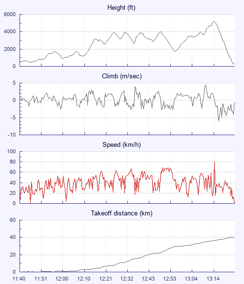
Found a blue hole thermal, 4-5ms, rode it up above cloud base where it started forming around me. Decided to stick with it as I could see the outline of the sun above me. After a few hundred more feet I realised I couldnt see it anymore and the lift was increasing. I aimed downwind and stuck with it for a short while but it started getting seriously rough and still lifty. I started a spiral still in whiteout, and realised I had lost a sense of the horizon, and wasn't too sure how to safely exit. After only 1 turn wasn't sure if I was going up or down, and how steep my spiral was, but felt a sharp airspeed and G increase. My right arm basically made the decision for me, and reserve came out quick but invisibly as it was cloud colour (looking back and not seeing it as my wing feel in front of me was awful). For about 20 seconds, my vario was reading -1ms under reserve but then came out the bottom and went to -5. I wouldn't call the deployment 'panicked' but instinctual instead.

Use this page to set various display Options. You can choose which units are used to display flight data, which map to show when the starts and which tab to show each time you view a flight.
Units settings

Metric units are used by default for the Statistics and XC Player pages, except for Height data which is shown in feet. You can choose your own custom settings here.

Height:
Speed:
Climb:
Distance:
  Use default
XC Player settings

When the XC Player starts, the track data is shown on the Hybrid map. You can choose a different map here.

Main Map:
  Use default
Tab settings

The first tab shown when you view a flight is the Flight Map. You can choose a different tab here.

First Tab:
  Use default
Notes

This page uses cookies to save your settings for future visits.

If you have disabled cookies for this site then any changes you make will not be saved.