Xc Title
User:Guest
Cloudbase Paragliding advert
Andrew Craig  All flights
Thames Valley League 2016
Flight type image
Turnpoint Flight on a Paraglider
Club
Southern
Glider
Nova Mentor 3 Light
Date
25th February 2016
Start
11:20
Finish
12:43
Duration
1hr 22mins
Takeoff
Combe Gibbet
Landing
Sutton Scotney
Coords
Takeoff
51.35843, -1.47997
Start
51.35860, -1.47997
TP1
51.35518, -1.50575
TP2
51.35948, -1.47892
TP3
51.36012, -1.48907
Finish
51.18067, -1.29677
Landing
51.18190, -1.29843
Distances and Score
Leg 1
1.84k
Leg 2
1.93k
Leg 3
0.71k
Leg 4
24.06k
Total
28.54k
Score
28.5
Open Distance
Total
24.5k
Filename
Use full pilot name
Download
Validated
Yes
Flight map
Notes

This map gives an overview of the flight, using the turnpoints to plot the track.

Use the for a detailed map and flight track.

Duration 0:00   Takeoff Distance 0
Controls
To animate the flight: click a point on the track, use the slider, or click the Play button.
slider
slider
Speed
Speed
Slower
Faster
Track color
No data
Highlights
Track data
Time: No data
Height:
Climb:
Speed:
Interval:
Units
Height: metres
Climb: m/sec
Speed: km/h
Distance: km
chart
Notes

Climb and Speed averaged over 4 second intervals.

These values may be lower than those shown by a flight instrument, which has access to continuous raw data.

Metric units are used for all chart data, except for Height which is shown in feet.

Height   -   GPS data
Maximum Height
[12:08:56]
3353 ft
Lowest Save
[11:35:14]
787 ft
Takeoff Height
[11:20:31]
892 ft
Landing Height
[12:44:20]
259 ft
Total Ascent 6985 ft
Height Gain
Above Takeoff 2461 ft
Maximum 2566 ft
Low Point
as Lowest Save
787 ft
High Point
as Maximum Height
3353 ft
Units
Climb   -   Pressure data
Maximum Climb
[11:40:56]
2.8 m/s
Minimum Climb
[12:36:04]
-3.5 m/s
Units
Speed
Maximum Speed
[12:12:04]
58.5 km/h
Average Speed
around course
20.7 km/h
Average Speed
over track length
32.6 km/h
Units
Tracklog
Flight Duration 1hr 23mins
Track Points 2526
Recording Interval 2 secs
Statistics Interval 4 secs
Track Length 45.6 km
Units
Flight instrument
Type Oudie 3
Model Not Set
Firmware 6.50.001
Notes

Climb and Speed averaged over 4 second intervals.

These values may be lower than those shown by a flight instrument, which has access to continuous raw data.

Average Speed around course is measured from Start to Finish points.

Track Length is the cumulative distance between track points from Takeoff to Landing.

You can change the default units displayed - see the Options page.

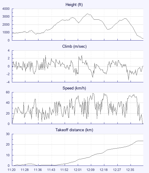
Arriving just after 10, I saw several gliders already doing well. A short early flight left me chilled through, so I put on two pairs of inner gloves under big outers, with a disposable heat pack in each, as well as one in a chest pocket. That made life in the air just about bearable. Hight had become harder to come by until a gaggle found ourselves in a steady climb, with three higher up and Nik Valiris, a blue and orange Advance and I chasing them.

The first climb fizzled out for us at just under 3,000, with the leaders still higher. After a short glide Nik caught them up, with the Advance and me climbing underneath them. On glide, I was reluctant to push bar because I knew the extra airspeed would chill me even more, but it had to be done. I fell away from the Advance and got low on my own, but a climb near Whitchurch turned good and Nik came to join me again. From there we glided to the A303 under increasing spreadout, with Nik almost managing to work a low save over what became our landing field.

I thought my heat packs had failed, but in fact they were still warm; without them I might have had to land earlier (they were still warm when I got home just before 1800, a good seven hours after I opened them)

The farmer came to make sure we weren't unauthorised ramblers, but didn't offer us a lift, so we set off to walk the couple of miles to Micheldever station. Trains to Winchester, Reading and Hungerford were followed by a very kind lift up the hill from Steve Spring.

It was my first British cross-country in February. It looks as if the rotten winter is truly over!

Use this page to set various display Options. You can choose which units are used to display flight data, which map to show when the starts and which tab to show each time you view a flight.
Units settings

Metric units are used by default for the Statistics and XC Player pages, except for Height data which is shown in feet. You can choose your own custom settings here.

Height:
Speed:
Climb:
Distance:
  Use default
XC Player settings

When the XC Player starts, the track data is shown on the Hybrid map. You can choose a different map here.

Main Map:
  Use default
Tab settings

The first tab shown when you view a flight is the Flight Map. You can choose a different tab here.

First Tab:
  Use default
Notes

This page uses cookies to save your settings for future visits.

If you have disabled cookies for this site then any changes you make will not be saved.